The shipping canal connecting the Gulf of Gdańsk with the Vistula Lagoon crosses the Vistula Spit 19 and 12 M east of Górki Zachodnie and the mouth of the Vistula River (Przekop Wisły), respectively, 22 M south-east of Hel, 13 M west of the state border with Russia at the spit, 3 M in a straight line to the east of the port of Kąty Rybackie on the Lagoon and 5 M to the west in a straight line from Krynica Morska. The canal is part of the harbour named Nowy Świat.
Nowy Świat Harbourmaster VHF Ch 68 (a VHF radio is obligatory), tel. +48 58 347 39 72, +48 662 186 934, office hours 6.30–18.30, e-mail: kpns@umgdy.gov.pl.
|
locking hours |
||
|---|---|---|
|
opening the entrance gate |
closing the entrance gate |
opening the exit gate |
|
from the Gulf to the Lagoon |
||
|
8.30 |
9.30 |
10.30 |
|
13.30 |
14.30 |
15.30 |
|
from the Lagoon to the Gulf |
||
|
11.00 |
12.00 |
13.00 |
|
16.0 |
17.00 |
18.00 |


The shipping channel consists of (north to south): a spacious outer port with an entrance facing north-west, mooring quays in front of the lock, funnel-guide quays running down to the lock (without mooring facilities), a lock measuring 200 by 25 m, guide quays on the southern side of the lock (no mooring facilities), mooring quays on the inside of the breakwaters at the Vistula Lagoon. The total length of the canal, from the heads on the Gulf to the heads on the Lagoon, is 1.25 M.
The lock gates slide into the quays. Two swing road bridges are located at the outside of the gates – one of the bridges is always closed to shipping and open to vehicle traffic. The clearance of these bridges in the closed position is 4.6 m.
Mooring of recreational craft awaiting lockage is possible with the consent of the harbourmaster at the quays on both sides of the lock (not to be confused with the quays of the outer port, see also below). In radio communication, the harbourmaster uses in relation to these berths terms such as “north-western quay” (nabrzeże północno-zachodnie), “south-eastern quay” (nabrzeże południowo–zachodnie) etc., as indicated on the plan. These guays are tall, equipped with large, round, black fenders mounted diagonally. Mooring bollards are installed on the quays (high) and in the recesses of the quay walls (about 70 cm above the water surface). Getting out to the quay from the deck of a low yacht is difficult. Ladders descending to the water are installed on the quays every 25 m. Each of the quays, in two places, near its end and beginning, has lowered fragments, about 10 m long each, convenient for mooring small vessels. The lowered section of the north-west quay is reserved for the Border Guard and the Police. The Harbor Master’s Office agrees to short mooring at the remaining lowered fragments of the quays, in order to, for example, disembark or pick up a crew member, rather not for a longer stay.
At the Gulf side mooring is basically also possible at the southern and western quays of the outer harbour. However, these quays are equipped with plastic, rectangular fenders, installed on jibs extending from the quay wall for several dozen centimeters – it is very difficult to get out of the yacht there. Attaching the mooring ropes is difficult too – poles are located only high at the quay. As a last resort, you can try to tie a long rope around the plastic fender. A lowered, convenient for mooring, short section of the quay is located at the western breakwater, near the head.
Locking takes place at specific times (given in the table), twice a day in each direction. VHF notification of the intention to enter the port and lockage is required. Having a VHF radio is obligatory – vessels without a radio are indeed not permitted to enter the waters of the harbour. The port regulations state that notifications must be made two hours in advance. In practice, the harbourmaster accepts much later notifications. You can enter the lock shortly before the entrance gate closes.
Diagonal, flat strips of rubber are installed on the walls of the lock (more convenient than diagonal fenders at the outer berths). Mooring bollards are placed high on the quays and in recesses about 70 cm above the water surface, as on the outer quays. The ban on the use of own fenders contained in port regulations, which is absurd in relation to small recreational craft, is widely ignored. Locking, i.e. closing one gate, closing and opening swing bridges, opening the other gate, takes about an hour (minimum 45 minutes).
The harbourmaster gives via radio commands to particular boats to enter the lock, indicates a specific place for mooring in the lock, and directs leaving the lock. Traffic lights are also used:
|
lights |
meaning |
|
|
⬤⬤ |
two red solid | no entry/exit, gates closed |
|
⬤⬤ |
two green |
entry/exit allowed |
|
◯⬤ |
white, green |
permission to leave the lock for boats moored to starboard |
|
⬤◯ |
green, white |
permission to leave the lock for boats moored port side |
|
⬤⬤ |
green, yellow |
entry/exit permit for vessels less than 4.60 m high |
|
⬤⬤ |
czerwone, żółte |
no entry/exit, vessels less than 4.60 m high may sail from the opposite direction |
|
⬤⬤ |
two red flashing |
serious failure/emergency |
The following speed limits apply in the port and its vicinity: on the roads – 9 knots, on the approach fairway to the heads – 7 knots, between the heads and the entrance to the funnel-shaped guides – 4 knots, in the guides and in the lock – 3 knots.
The difference in water levels between the Gulf and the Lagoon is usually very small or none. Only after storms it can be significant (occasionally up to 1 m). However, the gates on both sides of the lock are never open at the same time – the free flow of water between the Gulf and the Lagoon is not allowed for environmental reasons.
The area around the harboumaster’s office, along with the western quay of the lock, is fenced and in principle inaccessible to outsiders. The other quayes are open to the public. There are no toilets or any other land facilities available to the crews of the vessels moored in the harbour.
Approach
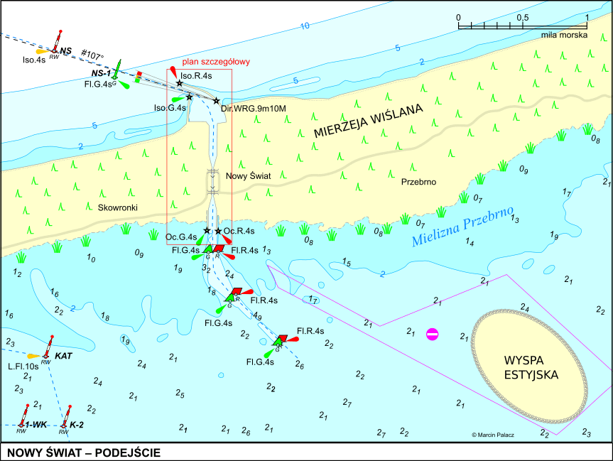
The beginning of the approach from the Zatoka side is marked by the “NS” light buoy, set approx. 1 M in front of the heads. From the buoy to the heads, you should steer the course 107°, indicated by the sector light on the breakwater (also visible in daylight), passing the green NS-1 and NS-3 buoys. The depths around this fairway exceed 5 m everywhere, so recreational vessels can head directly to the heads from a wide sector from the west to the north, without having to pass near the NS buoy (the 5 m isobath runs approximately parallel to the shore, at a distance of approx. 0.2 mm from it). The heads of the breakwater should be passed at a safe distance due to the underwater riprap, marked with yellow buoys.
On the Lagoon side, a fairway marked with red and green buoys will lead to the canal. In autumn 2022, dredging and marking of this fairway is in progress – only three pairs of buoys (the closest to the canal) are displayed. Yachts with a draft not exceeding 1.5 m can sail freely outside this fairway, paying attention to the coastal shallows, especially the Przebrno Shoal (Mielizna Przebrno), located by the spit, between the canal and Krynica Morska. On the occasion of the construction of the canal, an artificial island was created on the lagoon – the Estyjska Island (Wyspa Estyjska)– on which the spoil excavated during the construction of the canal and the dredging of the fairway is deposited. In principle, it is possible to sail on the northern side of the island, between the island and the Przebrno Shoal (approx. 2 m deep). This route, however, is intersected by a prohibited area, stretching between the island and the entrance to the canal.
Other information
The name of the place – Nowy Świat, i.e. New World or Neue Welt in German – comes from the name of the settlement existing there until 1945. This area in the interwar period (1920–1939) belonged to the Free City of Gdańsk. About 2 km east of the settlement (and the today’s canal), the state border between the Free City of Gdańsk and German East Prussia was situated.
The canal was officialy opened on 17 Septermber 2022.
Plans in PDF format: Nowy_swiat.pdf Nowy_swiat_podejscie.pdf